UK River Prize > 2022 UK River Prize
 |
Congratulations to the 2022 Winners! |
| 2022 UK River Prize | |
|
The UK River Prize celebrates the achievements of those individuals and organisations working to improve the natural functioning and ecological integrity of our rivers and catchments, and recognises the global benefits to society of a healthy natural environment. It is a collaboration across England, Wales, Scotland and Northern Ireland to celebrate best practice across the four countries. The UK River Prize is awarded by the River Restoration Centre (RRC). It is judged by a panel of UK experts. The UK River Prize winners were announced on 28th June 2022 at the UK River Prize Awards Dinner, in association with the RRC Annual Network Conference in Warwickshire. |
|


|
2022 UK River Prize Winners |
|
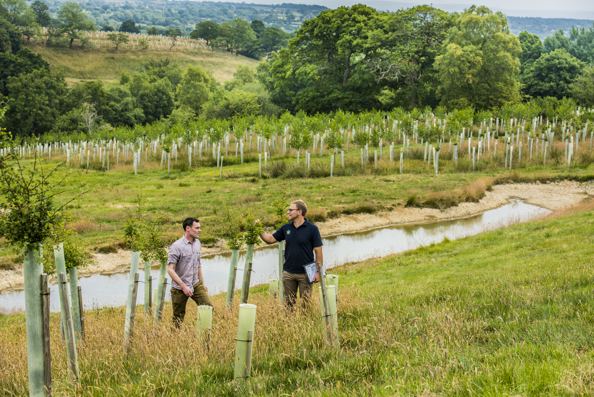
Ribble Life Together, River Ribble, Lancashire & Yorkshire, England Catchment-scale award Partners: Ribble Rivers Trust |
|
|
Ribble Life Together (RLT) brought together a range of stakeholders, interest groups and the communities through the Ribble Life Partnership. Using a prioritised ecosystem service approach, the project aimed to improve the natural river heritage of the Ribble Catchment for people and wildlife in an inclusive and integrated way. RLT brought many organisations together who all have a common goal of improving water quality, reducing the risk of flooding and droughts and increasing river connectivity and biodiversity. |
|
|
A key driver of the project was to make significant improvements to our river system by delivering an ambitious programme of river channel improvement projects and habitat creation projects. This would include 14 fish pass or weir removal projects, 30 new woodlands and delivering 14 wetland projects. These would vary in size and scope, designing bespoke projects for each location that would reflect and enhance local conditions and needs, and provide multiple benefits for the river and local community. For example, partial weir removals, rock ramp fish pass projects, technical fish pass projects, bypass channels, leaky dams, peat restoration, wildlife ponds and riparian woodlands that create wildlife corridors and strengthen habitat networks. |
|
|
Alongside the improvements to our rivers, Ribble Life Together aimed to connect people to their rivers and our work on a scale never achieved before. It aimed to reach new audiences and grow awareness throughout the catchment about the issues our rivers face. This included a catchment wide farm advice programme, working with farmers and landowners to increase knowledge about soil and water resource management, build trust and develop new environment friendly farm improvement and habitat creation projects. We would increase engagement with rivers through our education programme, volunteering, apprenticeships, public events. We would make our rivers more accessible through art projects, guided walks and by creating digital, online content such as short films that would allow people, who otherwise would not be able to visit their local river, to experience and learn about the riverscapes around them. We wanted people to explore and celebrate the rich heritage of the river and encouraging more people to discover the wonder of the river for themselves. The result would be a healthier river system and a catchment that would be a better place to work, live and visit, whilst also engaging people in their local rivers and encouraging them to take positive action to conserve and improve them. |
|
|
2022 UK River Prize Finalists |
|
Albany Park River Restoration Project, Turkey Brook, London Borough of Enfield, England Partners: Enfield Council, Environment Agency |
|
|
The Albany Park River Restoration project was led by Enfield Council working closely in partnership with the Environment Agency. Albany Park is a large open space in the north-east of the London Borough of Enfield. Prior to delivery of the scheme, the Turkey Brook main river ran along the northern boundary of the park in a heavily engineered channel with concrete and masonry walls on both sides. Consequently, the river was not an integral part of the park – it could only be viewed when standing close to the top of the concrete wall. |
|
| The project was initially proposed in 2014 during a public consultation however at the time there was no funding available to carry out this major piece of work. Enfield Council and Environment Agency developed a scheme that improves the river while simultaneously reducing flood risk – achieved by excavating a large volume of soil and using the spoil to create a flood bund on the far side of the park, making space for water and creating a flood storage area that can store 50,000m3 of water during extreme flood events. | |
|
The project involved restoring 400 metres of Turkey Brook by excavating a new naturalised channel that brings the river into the park. This has transformed the park, creating interesting spaces for people to explore and dramatically increasing the range of wildlife – kingfishers, egrets and dragonflies are all now commonly sighted. As well as creating new habitat for wildlife and a diverse landscape for park users to enjoy, this work facilitated the creation of a flood storage area that reduces flood risk to over 400 properties. The project improves biodiversity by creating a range of new habitats including wetland, woodland and wildflower meadow. It also improves the amenity and educational value of the park by including an outdoor classroom and improves access to nature through the provision of new footpaths. Constructed wetland features help to mitigate the impact of urban pollution from the local drainage network. |
|

|
Castle Acre Common WEG Project, River Nar, Norfolk, England Partners: Norfolk Rivers Internal Drainage Board, Environment Agency, Natural England, Norfolk Rivers Trust |
|
|
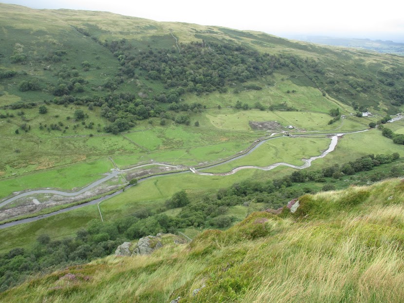
The River Nar Restoration Steering Group is an open coalition of stakeholders including the Norfolk Rivers Internal Drainage Board, Environment Agency, Natural England and The Norfolk Rivers Trust, together with land-owners including West Acre, Holkham and Narford Estates, a number of fishing clubs and other interested parties, collaborating to achieve a long-term catchment restoration of the River Nar. The primary driver was the restoration of hydrological connectivity and process-driven self-restoration to a 2km section of the river that had historically been diverted to the edge of the floodplain and perched to build up a head of water to drive a mill. This type of channel diversion and perching is common on chalk streams, and has the effect of divorcing the river from the floodplain, and of lowering the gradient over long reaches. This creates a sediment retention issue, especially now that the mills are not worked, which has historically, in turn, precipitated dredging/management works which have tended to exacerbate the problems. Diffuse agricultural pollution becomes locked within these sorts of channels, leading to nutrient spiralling – from the sediment to the water-column and back again – each time flows or other activities disturb the bed material. But at no point can the river flush, escape its banks or place this nutrient loading on the floodplain. The nutrient enrichment and channel morphology skews the habitat in favour of a more limited and pollution-tolerant community of invertebrates and plants. |
|
|
In the pre-existing channel there was a notable absence of ranunculus. The overall aim, then, was to restore the channel to the centre of the floodplain and thus to restore the true gradient, natural channel dimensions (which will allow high flows to escape the banks and flood marginal habitats) and a natural meandering planform and pool-riffle sequence, enlivened by large woody debris together with floodplain wetland features (Stage Zero) over parts of the project site: with the overall aim of restoring hydrological connectivity between the river and supporting floodplain and of increasing biodiversity and favourable habitat for rheophilic species of fish, plants and inverts. Planning involved a full topo survey to establish the best corridor for the new channel, assessment of historic maps and nearby relic and existing natural meanders to form baseline dimensions and the careful plotting of a course that navigated the new channel along a line that would find gravel at the correct depth for the projected bed level (so that gravel was neither too shallow, not too deep along the chosen course) and which also incorporated relic sections of the original channel and various ditch networks subsumed into the project as wetland features. |
|

|
Follow @UKRiverPrize to keep up to date |
| 2022 Partners | |||
|
|
|||
|
Find out more about the UK River Prize and previous winners >>> |
|||